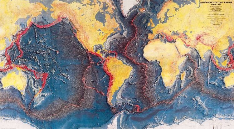
The science of seismicity is the study of how seismic waves propagate through the Earth, including the study of earthquake sources and mechanisms, and the enhancement of our knowledge of the Earth’s structure through variations in seismic wave properties. Computers with high performance are typically required for quantitative analysis. Using seismology, it is possible to map the structure of the deep parts of the Earth. There are hundreds of seismic stations around the world.
The calculation of changes in Earth’s properties at different locations can be accomplished by analyzing seismic waves propagating from natural and artificial sources, such as earthquakes, nuclear explosions, and other events related to seismic waves. According to the equation, seismic wave velocity would increase smoothly with depth if the Earth contained a uniform composition since density corresponds to seismic velocity.
Nevertheless, seismologists have found that, when plotting the observed arrival times of seismic waves, velocities don’t increase steadily with depth, but rather change dramatically at discrete boundary points and transition zones deep within the Earth. Seismologists calculate the positions and changes across these zones by noting several different properties of seismic waves.
Some are reflected off interfaces, just as light is reflected off surfaces, and other waves are refracted, changing the velocity and path of the rays. Wave velocity maps are used to determine the locations of the boundaries where reflections and refractions occur on Earth and where they occur. The core-mantle boundary at 1,802 miles (2,900 km) depth in the Earth strongly influences both P- and S-waves.
It refracts P-waves, causing a P-wave shadow and, because liquids cannot transmit S-waves, none gets through, causing a huge S-wave shadow. These contrasting properties of P- and S-waves can be used to map accurately the position of the core-mantle boundary. Other main properties of the deep Earth can be deduced from the variation in the propagation speed and direction of seismic waves. Velocity gradually increases with depth, to about 62 miles (100 km), where the velocity drops slightly between 62–124 miles (100–200 km) depth, in the low-velocity zone.
The reason for this drop in velocity is thought to be small amounts of partial melt in the rock, corresponding to the asthenosphere, the weak sphere on which the plates move, lubricated by partial melts. Another seismic discontinuity exists at 248.5 miles (400 km) depth, where velocity increases sharply due to a rearrangement of the atoms within olivine in a polymorphic transition into spinel structure, corresponding to an approximate 10 percent increase in density.
At 416 miles (670 km), there may be a major Science of Seismicity discontinuity caused by either another polymorphic transition or an alteration in composition. Current research has focused on investigating this. Depending on the model, this boundary may separate two fundamentally different types of the mantle, which circulate in separate convection cells, or it may induce more interaction between rocks above and below that discontinuity. Core-mantle boundaries are among the most fundamental features on the planet, with a large density difference between the upper and lower core.
The change is greater than the difference between rocks and air on the surface. Most of the outer core is made up of molten iron. The core also contains another discontinuity at the boundary between the liquid outer core and the solid, iron-nickel inner core. In addition to studying seismic waves, we can also examine the structure of the Earth’s crust. Andrija Mohorovic*ic, from Volosko in Croatia and a seismologist in Yugoslavia, observed slow and fast arrivals from earthquake source events nearby.
There is a deep Science of Seismicity discontinuity between seismically slow and fast material at about 18.6 miles (30 km) depth that causes some seismic waves to travel through the crust, some to travel along the surface, and others to be reflected off. These boundaries, known as the Mohorovicic (or Moho) boundary, are now recognized as the base of the crust. Geophysicists use the seismic positions of these boundaries to determine the thickness of the crust, ranging between 6.2 and 43.5 miles (10 and 70 km). Read More – Year of Impossible Goodbyes – By Sook Nyul Choi
